The Map of the 5th Armored Division in Europe
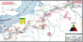
Map photo courtesy of Bill Appleby
At war's end, each of the men were provided a set of maps to chronicle the division's military might
and speed against the Germans. In all, there were three maps. The one listed on this page is titled,
"The Trek of the Fifth Armored" and provides an overview of their path from Swindon, England to the edge
of Berlin. The other two maps are, "Normandy to the Seine" and "Rhine River to the Elbe".
Click on any map to view a full size version of that map.
NOTE: These are very large maps with a lot of detail. Once the map has loaded you can resize it by holding down the Ctrl key and rotataing the mouse wheel.
Map of the 5th Armored's Trek from Normandy to the Seine River
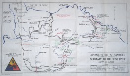
Map photo courtesy of Greg Smith
Map of the 5th Armored's Trek from the Seine River the the Rhine River
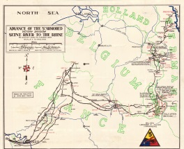
Map photo courtesy of Dan Salmon, grandson of John McMahon; 5th AD Veteran
Map of the 5th Armored's Trek from the Rhine to the Elbe
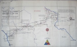
Map photo courtesy of Greg Smith